1/8
Geotagging+ screenshot 0
Geotagging+ screenshot 1
Geotagging+ screenshot 2
Geotagging+ screenshot 3
Geotagging+ screenshot 4
Geotagging+ screenshot 5
Geotagging+ screenshot 6
Geotagging+ screenshot 7
Geotagging+ Icon

Geotagging+

Nuaim Hammad Ausi
Trustable Ranking Iconمورد اعتماد
1K+دانلودها
17MBاندازه
Android Version Icon4.0.1 - 4.0.2+
إصدار الأندرويد
1.1(29-06-2018)آخرین نسخه
-
(0 دیدگاه‌ها)
Age ratingPEGI-3
دانلود
جزییاتدیدگاه‌هانسخه‌هاالمعلومات
1/8

توضیحات Geotagging+

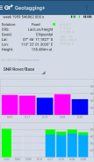
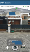
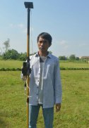
This app allows you to take image and measure with low-cost GNSS module (like U-blox GNSS module or E-GNSS from potretudara : http://www.potretudara.com/low-cost-gps-gis/ ). Measured coordinates from low-cost GNSS module are stored to EXIF image metadata in time when you tap the "capture" button. Use this to create your geotagging more precise to sub-meter level. Very useful for census, GIS support, reporting issue, and others.


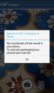
You can still use internal GNSS for geotagging by deactivate BASE and ROVER in the Input Stream menu. Obviously none of the precision algorithm found in RTKLIB can be use.


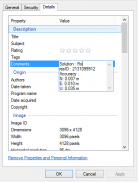
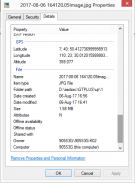
Image taken by this app will have coordinate metadata, accuracy, and solution type (internal, single, float, or fix).


Heavily based on RtkGps+ from Ronan LE MEILLAT, this is a fork of his work. Original licenses are in the "About/Legacy Info" screen. Thanks to all contributors to respect this clause.


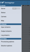
This app is RTKGPS+-like with additional Camera menu. You still can use this app for surveying, tracking, etc. like RTKGPS+ do.


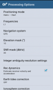
This app is a port of RTKLIB 2.4.3b 28 developed by Tomoji Takasu (http://http://www.rtklib.com/). This RTKLIB 2.4.3 is modified by rtklibexplorer and named RTKLIB 2.4.3 demo 5 b 28 (https://github.com/rtklibexplorer/RTKLIB). If you do not know what this application is, this application is probably not what you are looking for!


App manual : http://bit.ly/shortmanual

Geotagging+ - نسخه 1.1

(29-06-2018)
سایر نسخه‌ها
تازه‌ها* Merge to RTKLIB demo 5 b 28 (update rtklibexplorer 5/8/2017)* Add Height-metadata on photo taken* Fix solution-metadata (internal/single/float/fix) on some devices* Fix input negative LLH/ECEF coordinate base station position

هنوز هیچ دیدگاه و نظری وجود ندارد! برای ثبت اولین دیدگاه لطفا روی کلیک کنید.

-
0 Reviews
5
4
3
2
1

Geotagging+ - اطلاعات APK

نسخه APK: 1.1حزمة: com.geotaggingplusfree
سازگاری با اندروید: 4.0.1 - 4.0.2+ (Ice Cream Sandwich)
برنامه‌نویس:Nuaim Hammad Ausiشرایط حریم‌خصوصی:https://github.com/ausiozمجوزها:12
نام: Geotagging+اندازه: 17 MBدانلودها: 7نسخه : 1.1تاریخ انتشار: 2018-06-29 18:52:35حداقل صفحه‌نمایش: SMALLپردازشگر پشتیبانی‌شده: x86, armeabi, armeabi-v7a, mips
شناسه بسته: com.geotaggingplusfreeامضای SHA1: F8:CE:A3:16:6D:39:C8:BD:54:40:88:1D:00:FA:C3:DF:1A:F9:16:9Cبرنامه‌نویس (CN): Nuaim Hammad Ausiسازمان (O): منطقه (L): کشور (C): استان/شهر (ST): شناسه بسته: com.geotaggingplusfreeامضای SHA1: F8:CE:A3:16:6D:39:C8:BD:54:40:88:1D:00:FA:C3:DF:1A:F9:16:9Cبرنامه‌نویس (CN): Nuaim Hammad Ausiسازمان (O): منطقه (L): کشور (C): استان/شهر (ST):

آخرین نسخه Geotagging+

1.1Trust Icon Versions
29/6/2018
7 دانلودها17 MB اندازه
دانلود
appcoins-gift
بازی‌های بونوسجایزه بیشتری ببرید!
بیشتر
Super Sus
Super Sus icon
دانلود
Nations of Darkness
Nations of Darkness icon
دانلود
Clash of Kings
Clash of Kings icon
دانلود
RAID: Shadow Legends
RAID: Shadow Legends icon
دانلود
Clash of Kings:The West
Clash of Kings:The West icon
دانلود